The Blue Line Metro Dubai was approved with an AED 18 billion budget, construction began in June 2025, and the target opening date is 9 September 2029. This article covers what the line actually connects, which communities stand to benefit most based on historical metro impact data, and how investors can position ahead of the 2029 launch.
Dubai Metro Blue Line: What It Really Builds for Dubai Real Estate
The Blue Line is Dubai's third metro line a 30-kilometre, 14-station Y-shaped corridor that fills the gap in the city's existing east-west connectivity. The Red Line runs roughly north-west to south-east. The Green Line covers historic Deira and Bur Dubai.
The Blue Line connects communities that neither reaches: the eastern residential and academic belt stretching from Festival City through International City to Silicon Oasis and Academic City, plus a second branch from the Red Line's Centrepoint station through Mirdif and Al Warqa.
The two branches converge at an underground interchange station at International City 1. From there, the longer branch runs 21 kilometres from the Green Line's Creek station through Dubai Festival City, Dubai Creek Harbour, Ras Al Khor, and International City before continuing to Dubai Silicon Oasis and Academic City. The shorter branch, four stations, connects Mirdif and Al Warqa to the same interchange.
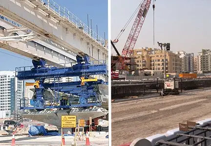
Construction was 10% complete as of November 2025, five months after ground broke in June 2025. The RTA projects approximately 30% completion by the end of 2026, with the line on track for its September 2029 opening. The project is on track. As of early 2026, the Emaar Properties station at Dubai Creek Harbour is confirmed as the first station built and will become the world's tallest metro station, designed to handle 160,000 passengers daily.
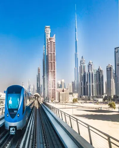
The line will carry an estimated 320,000 passengers daily once fully operational, according to RTA capacity projections released at the Blue Line groundbreaking in June 2025. That is not a marginal addition to Dubai's transit network.
Dubai Metro and Property Prices: What History Reveals
Dubai has done this before, twice. When the Red Line opened in 2009, communities within a 15-minute walk of its stations recorded price increases of more than 25% in the years that followed. Between 2009 and 2014, areas like Dubai Marina and JLT saw 80% to 100% price growth driven by post-crash market recovery, community maturation, and metro access combined. Metro connectivity was a significant and documented contributor, though not the sole factor in play.
The mechanism is straightforward. Metro access lowers the effective cost of living by removing car dependency. Tenants pay less in transport and time. That makes metro-adjacent units worth more, they attract better tenants, lease faster, and hold value through soft periods better than comparable non-metro stock.
Also, Industry executives quoted in Gulf News shortly after the Blue Line groundbreaking noted that well-located assets along the Blue Line corridor are forecast to outperform the broader Dubai market by up to 5% in capital value appreciation as connectivity improves. That estimate is based on historical precedent, not speculation.
Industry analysts project up to 25% property value appreciation near completed stations once the line opens. Whether the final number lands at 10% or 25% depends heavily on individual building positions. But the directional case is solid.
Dubai Blue Line Metro: Top Communities Set for Growth
The rent data from mid-2025 is already telling the story, three and a half years before the trains run.
Academic City saw the sharpest rental jump following the Blue Line announcement, studio rates rose from AED 42,000 to AED 60,000, a 43% increase, according to Khaleej Times data from June 2025. That is not a normal market move. Academic City hosts 27 universities. An estimated 50,000 students are projected to use the Blue Line by 2029. Students and faculty who currently depend on buses and private cars will be able to reach Downtown and DIFC directly. The demand for rental units here shifted as soon as the route was confirmed.
Dubai Creek Harbour recorded a 30% rent increase in the same post-announcement wave. Creek Harbour already carries Emaar credentials and a waterfront address. The metro connection converts it from a premium community with a commuting problem into a premium community with genuine city-wide connectivity. That is a meaningful upgrade. Property value appreciation for Creek Harbour is estimated at up to 20% from the Blue Line effect alone, on top of the 28% price-per-square-foot growth it already posted between Q1 2023 and Q3 2025.
Dubai Silicon Oasis posted the highest price jump of any community following the Blue Line news: 29% per square foot, according to Gulf News 2025 market data. DSO apartment prices rose between 60–80% between 2022 and 2024. It hosts a tech park, over 88,000 residents, and a growing professional tenant base. It was one of Dubai's best yield communities for investors. It lacked a metro stop. That gap closes in 2029.
International City and Mirdif both recorded 22% and 15% rent increases, respectively, in the same wave. "International City has consistently delivered some of Dubai's highest apartment yields. According to Bayut's Dubai Sales Market Report 2025, the current ROI sits at 7.67% for studios and 7.44% for 1-bedroom apartments still among the top-performing communities in Dubai. These figures are post-Blue Line announcement, meaning they already reflect the 22% rent increase the area recorded in mid-2025. Before the announcement, studios were averaging close to 9.7% ROI compressed by rising rents pushing purchase prices up alongside them. Metro access will continue to compress that yield gap with premium areas as more buyers treat International City as a credible long-term hold."
Dubai Property Investment Strategy: How to Position Before 2029
The most important thing to understand about infrastructure-driven appreciation cycles: the biggest gains typically go to buyers who enter before the infrastructure is complete, not after. By the time the Blue Line opens in 2029, much of the uplift will already be priced into units near confirmed stations.
For off-plan buyers, the window is now. Communities like Dubai Silicon Oasis and Academic City still have off-plan projects launching at prices that reflect today's limited connectivity, not tomorrow's metro access. Entering now locks in a base price before the 2027-2028 pre-opening appreciation run that historically precedes metro launches.
For ready-property buyers, the secondary market in International City and Mirdif is the most interesting play. International City units are still trading at entry prices, averaging around AED 690,000 to AED 700,000 for two-bedroom apartments ,despite having some of the strongest yield histories in Dubai. The Blue Line converts that yield-only argument into a yield-plus-appreciation argument.
RERA-registered advisors tracking this corridor recommend verifying walking distance to confirmed station locations before buying. Buildings within five to eight minutes of a station consistently outperform those ten to fifteen minutes away not by a small margin. That gap averaged 12% to 15% in historical Dubai metro impact studies. Station proximity is not a soft preference. It is a return variable.
One practical point on timing: avoid confusing the announcement effect with the completion effect. Rents and some sale prices already moved in 2025 on announcement news. The second wave larger and more sustained comes when trains actually run. Investors who entered in 2025 captured the first wave. There is still time to capture the second.
Dubai Metro Blue Line Limitations: What It Doesn't Solve
The Blue Line is not a correction for every underperforming community in east Dubai. Ras Al Khor Industrial Area gets a station. That improves logistics connectivity and worker commute patterns, but it does not turn industrial parcels into high-yield residential plays. The station is an infrastructure improvement for that specific land use, not a residential catalyst.
Academic City's 43% rent spike also came with a caveat: student tenant profiles carry higher turnover than professional tenants. Higher rent is welcome, but vacancy risk between semester cycles stays a real management consideration. Investors buying in Academic City need a property manager who understands that rhythm.
And the 2029 target date is a plan, not a guarantee. Infrastructure projects in Dubai have generally delivered close to their stated timelines , the original metro opened on schedule in 2009. But a large-scale civil engineering project through nine communities, including the first Dubai Metro bridge over the Creek, carries inherent schedule risk. Any buyer building a three-year exit strategy tied precisely to a September 2029 opening is taking a timing bet. A five-to-seven-year horizon absorbs that risk far more comfortably.
The Bottom Line
The Blue Line Metro Dubai is the most significant infrastructure catalyst for Dubai's eastern residential corridor since the original metro launched in 2009. Academic City, Dubai Creek Harbour, Silicon Oasis, and International City have already moved on announcement data. The deeper appreciation wave comes as trains approach and begin running. Investors with a five-to-seven-year horizon and a preference for transit-linked, mid-market communities still have a viable entry window.
If you want to map specific Blue Line communities and available properties to your investment budget, the team at Dubai Housing can help you identify station-adjacent opportunities before the 2029 opening reprices the corridor.